Quantcast
 
 
Make Memories Galore in Hampton Beach, NH in 2024! Click for beach cams & more information.

White Mountains covered bridges are a living example of engineering history

bath bridge
Bath Bridge

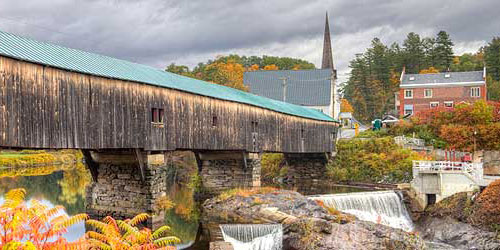
Pettyboro Road Bath, NH, 03740 Phone:

Location: West of U.S. Route 302 over the Ammonoosuc River

Built in 1832, the current structure is the fifth bridge to stand on this site. The first was constructed in 1794, demolished by a flood, and replaced in 1806. The second and third bridges were also destroyed by floods and replaced in 1820 and again in 1824. The fourth bridge was destroyed by fire in late 1830. Rebuilding efforts began in March 1831. Burr truss with supplemental arches; 374 feet long.
Blair Bridge

Blair Road Campton, NH, 03223 Phone:

Location: East of U.S. Route 3, two miles north of Livermore Falls

The first bridge at this location, which carries Blair Road across the Pemigewasset River, was built in 1829. That bridge was burned down by a man named Lem Parker who claimed that God told him to do it. The current bridge was built in 1869 after a doctor trying to ford the river on horseback found the current too strong. The horse drowned, but the doctor was saved. The town voted to build a bridge immediately. It was rebuilt by Milton Graton and his son Arnold in 1977. Long truss with arches; 292 feet long.
Sentinel Pine Bridge

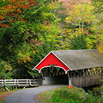
Location: in the Flume Gorge, Franconia Notch State Park

This bridge, built in 1939, is located in Franconia Notch State Park and it carries a hiking trail over the Pemigewasset River just a short distance from the Franconia Notch Visitors Center. It is considered a “romantic” structure, meaning that it is an authentic reproduction of a historic covered bridge, but built of materials other than timber, with no truss or arch. The covered portion of the bridge is 60 feet long. This bridge along with the Flume Bridge are all part of some of the natural attractions that make up the area generally known as the Flume.
Saco River Bridge

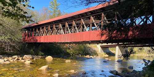
East Side Street Conway, NH, 03818 Phone:

Location: 0.4 miles north of the junction routes 16 and 153 on east side of road. In Conway Village go north on Washington Street and turn right at the fork; this is East Side Road.

This bridge, built in 1890 by Charles Broughton and his son, Frank, carries East Side Road over the Saco River a short distance north of Conway Center. In 1850s, Jacob Berry and Peter Paddleford built a covered bridge to replace a crudely framed log bridge that had collapsed at this site. The 1850 bridge stood until the Swift River covered bridge crashed into it in 1869 after that bridge was swept from its abutments. The bridge was rebuilt by Allen and Warren of Conway but it was destroyed again by a tannery fire in 1890. The existing structure replaces the one destroyed by the fire. Paddleford truss with added arches; 224 feet long. There is a small parking lot on the northeast side of the bridge.
Bath-Haverhill Bridge

route 135 Bath and Haverhill, NH, 03740 Phone:

Location: One-quarter mile north of U.S. Route 302 in Woodsville Village

Built in 1829, this bridge carries Route 135 across the Ammonoosuc River. It is the oldest covered bridge still in use in New Hampshire and the first and only bridge at this site. Town lattice truss with arches; 256 feet long.
Albany Covered Bridge - Albany, NH
Albany Bridge

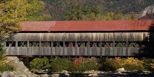
Passaconaway Road Albany, NH, 03818 Phone:

Location: Just north of the Kancamagus Highway, six miles west of N.H. Route 16

This bridge is located in the White Mountain National Forest, off the Kancamagus Highway. It carries Paccanaway Road over the Swift River just a short distance from the Covered Bridge Campground. The bridge was built in 1858, replacing an earlier bridge, built in 1857, that was destroyed by a wind storm. The U.S. Forest Service modified the structure in 1981-1982, replaced the wooden floor timbers with steel. Paddleford truss with added arches; 120 feet long. Parking available in a White Mountain National Forest parking lot near the bridge.
Swift River Bridge

Location: One-half mile north of N.H. Route 16 at Conway Village

The first bridge at this site, crossing the Swift River, was built in 1850. In 1869, it was swept off its abutments by the raging Swift River and it rode downstream into the Saco River, where it crashed into the Saco River bridge. Debris from both bridges was salvaged and used in rebuilding this bridge. In 1974, the bridge was bypassed in favor of a new concrete and steel structure. Paddleford truss with arch; 133 feet long.
Jackson Honeymoon Bridge

Main Street at Pinkham Notch Road Jackson, NH, 03846 Phone:

Location: From the intersection of Routes 16 and 16A, travel east on Route 16A

This bridge, built in 1876, carries Main Street (formerly called Village Street) across the Ellis River. Called Honeymoon Bridge because of a longstanding tradition of newly married couples having their photo taken at the bridge. A sidewalk was added in 1930. Paddleford truss with added arches; 121 feet long.
Turkey Jim’s Bridge

Old Stephan's Road Campton, NH, 03223 Phone:

Location: The bridge can be reached by driving into the campground just east of U.S. Route 3 and north of N.H. Route 49.

The original covered bridge on this site, which carries Old Stephan’s Road across West Branch Brook, was built in 1874. The bridge's name originates from farmer, Jim Cummings, whose property was known as Turkey Jim's Turkey Farm. The bridge was replaced in 1958 by Milton Graton. In 1964, the bridge washed downstream, was retrieved, and set back on its abutments. Open only to pedestrian and snowmobile traffic. Queenpost truss; 60 feet long.
Clark’s Bridge

Location: East of U.S. Route 3 in Clark's Trading Post on Clark's Short Steam Railroad

Clark's Bridge was originally built in Barre, Vermont, in 1904 as a part of the Barre Railroad, to span the Winooski River. In 1960 the railroad line and the covered bridge were abandoned. The bridge was dismantled in East Montpelier and taken to its present site. The bridge was reassembled on dry land next to the Pemigewasset River. It was positioned over the river in 1965 and is still used as a part of Clark's Short Steam Railroad. It appears to be the only Howe railroad bridge left in the world. Howe Truss; 116 feet long.
Bump Bridge

Bump Road Campton, NH, 03223 Phone:

Location: One mile east of N.H. Route 175 at Campton Hollow

The original Queenpost structure at this site was built in 1877. The bridge carries Bump Road across the Beebe River. At one time the bridge was known as the Webber Bridge. The current structure was built by Arnold Graton in 1972. Queenpost truss; 68 feet long.
Swiftwater Bridge

Valley Road Bath, NH, 03740 Phone:

Location: North of N.H. Route 112 over the Wild Ammonoosuc River

Built in 1849, this bridge carries Valley Road across the Wild Ammonoosuc River. This bridge is the fourth to cross the Wild Ammonoosuc River at this site. The first was built in 1810, carried away in 1818 by a flood and replaced in the same year. That bridge was destroyed by a flood in 1828. The third bridge was erected in 1829 and remained at the site until 1849. At that time it was dismantled and replaced by the current bridge. This bridge was rebuilt by the state in 1977. Paddleford truss with added arches; 158 feet long.
Bartlett Covered Bridge - Bartlett, NH
Bartlett Covered Bridge and Gift Shop

Near Route 302 Bartlett (Intervale), NH, 03812 Phone:

Location: West on U.S. Route 302, four and one-half miles east of Bartlett Village

This bridge, built in 1857, spans the Saco River. The bridge was abandoned and closed to traffic in 1939, and began to deteriorate. In the 1950s, it was used to store town equipment and snow fencing. In 1966 the bridge was purchased by a private individual who had it repaired and began to operate a gift shop inside the structure. The gift shop remains in business today, under newer owners, from Memorial Day through October. Paddleford truss with added arches; 166 feet long. Limited parking.